In a startling blend of modern technology and cold case investigation, a Florida man missing for over two decades was finally located when satellite images from Google Maps revealed his car submerged in a local pond. This discovery not only brought closure to a long-standing mystery but also showcased the unexpected ways in which digital tools are aiding law enforcement and families in resolving cases that once seemed beyond reach.
Background on the Case
William Moldt, a 40-year-old man from Lantana, Florida, vanished on the night of November 7, 1997, after leaving a nightclub. He was reported missing after he did not return home and failed to show up for work the following day. Initial searches turned up little information on Moldt’s whereabouts, leading to a cold case that puzzled investigators for years. Despite several leads and extensive search efforts, no significant progress was made, and the case grew cold, leaving family and friends without answers.

Discovery of the Car
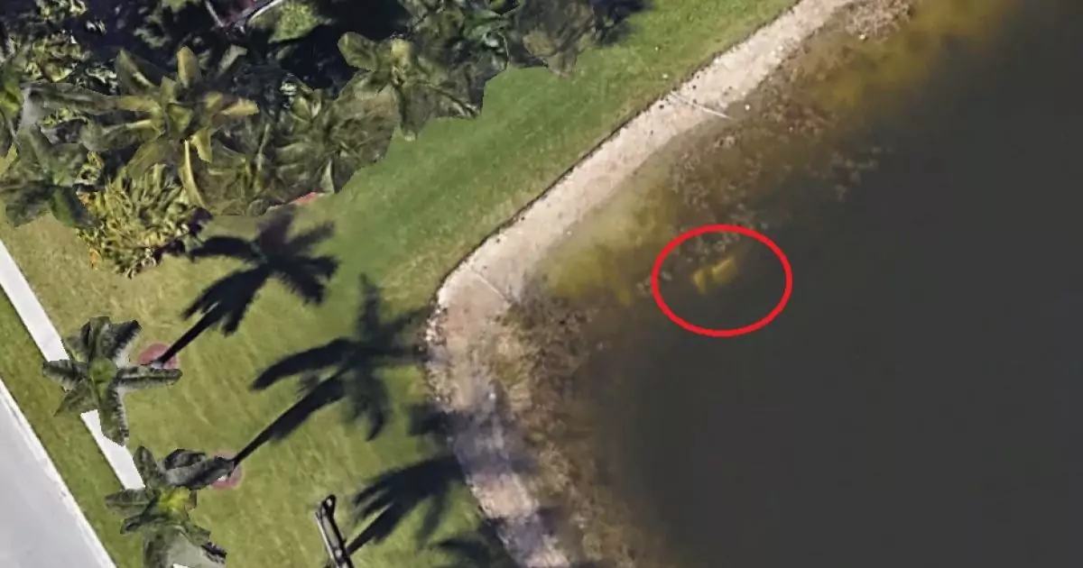
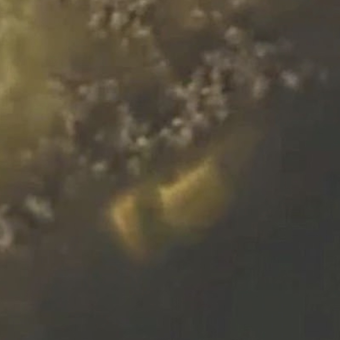
The breakthrough came in August 2019 when a property surveyor examining satellite images on Google Maps noticed something unusual in a pond in a housing estate in Wellington, Florida. The submerged object appeared to be a vehicle. Upon closer inspection and eventual retrieval, it was confirmed to be Moldt’s car, remarkably well-preserved and still containing his remains.
Role of Technology in Modern Investigations
The discovery of William Moldt’s car after more than two decades highlights the pivotal role that technology, especially satellite imaging and digital mapping, plays in modern investigative processes. Google Maps, known primarily for its navigation capabilities, inadvertently becomes a tool for law enforcement by providing detailed and sometimes updated satellite imagery of virtually every corner of the globe. This technology is not just a wayfinder but a new frontier in the world of law enforcement and public safety. Investigators now regularly use digital mapping and satellite images to revisit cold cases, scout crime scenes, and gather geographic data that was once inaccessible.
Digital imaging technology has advanced significantly since the late 1990s, with higher resolution images and more frequent updates. These advancements allow for a more thorough examination of remote areas and detailed views of changes over time in specific locations. This case serves as a testament to the unexpected ways digital advancements are aiding investigations, often providing the missing piece in puzzles that have baffled authorities for years.

Legal and Police Investigation
Following the identification of the car via satellite images, local law enforcement, along with a dive team, coordinated the retrieval of the vehicle from the retention pond. The car, which was visible only from satellite imagery and not from the roadside, required careful extraction to preserve potential evidence. Once retrieved, the vehicle confirmed the identity of the remains inside, leading to a reopening of the investigation into Moldt’s disappearance.
This phase of the investigation involved not only forensic analysis of the remains and vehicle but also a re-examination of the events leading up to Moldt’s disappearance. Police revisited old leads, interviewed previous suspects and witnesses, and collaborated with forensic experts to piece together the circumstances that led to the car ending up in the pond. This discovery prompted questions about the initial search efforts and whether anything was missed in the original investigation.
Visibility of the Car and Investigative Questions
The fact that Moldt’s car was not discovered earlier, despite presumably being submerged in a relatively accessible pond, raised several questions. Community members and the media questioned the thoroughness of the initial searches and whether the available technology at the time was adequately utilized. Experts suggested that changes in the water level over the years may have occasionally obscured or revealed the car at different times, complicating detection. Moreover, the growth of algae and silt could have camouflaged the vehicle, making it virtually invisible to casual observers from the surface.
This aspect of the case highlights potential gaps in the procedures used during the initial investigation and emphasizes the importance of using all available resources, including aerial and satellite imagery, in search efforts for missing persons. The incident has prompted law enforcement agencies to review and possibly update their protocols for using technology in search and rescue operations, ensuring a more exhaustive approach in future cases.
Reaction from the Family and Community
The resolution of the case brought a bittersweet closure to Moldt’s family, who had lived for 22 years without knowing what had happened to their loved one. His family expressed their gratitude towards the detectives and experts involved, relieved that they could finally have closure, yet saddened by the circumstances of his death. The local community and the media also took keen interest in the case, with many people amazed at how technology played a crucial role in solving the mystery.
Community discussions often centered around the potentials and limitations of technology in personal safety and criminal investigations. This case became a reference point in community safety meetings and local forums, emphasizing the importance of keeping personal and communal areas well-monitored and advocating for more widespread use of technology in public safety efforts.
Similar Cases
Moldt’s case is not unique in its resolution via technological means. There have been several instances where missing persons and unsolved crimes were aided by digital technology. For instance, in California, drone technology helped locate the remains of a hiker missing for several weeks in rugged terrain. In another case, advancements in DNA technology helped solve a two-decade-old murder mystery when forensic experts were able to match DNA from a crime scene to a suspect’s database.
These cases illustrate how technology is becoming an indispensable part of crime solving, providing authorities with tools that extend their capabilities far beyond traditional methods.
Implications for Future Investigations
The resolution of William Moldt’s case through the use of satellite imagery from Google Maps sets a precedent for the future of investigative work. This incident illustrates a burgeoning era where technology can intersect with traditional law enforcement techniques to solve mysteries that might otherwise remain unsolved. It underscores the potential for public access technologies to aid in law enforcement efforts and the need for agencies to harness these tools proactively.
Moreover, the Moldt case emphasizes the importance of agencies being open to revisiting cold cases with new technologies. The success found in using satellite imagery to locate submerged objects could lead to more systematic reviews of old cases, especially those involving missing persons or mysterious disappearances. The integration of artificial intelligence and machine learning could further enhance the ability to sift through massive amounts of data, including satellite images, to detect anomalies that warrant further investigation.
The legal implications are also significant. The use of technology in forensic science challenges existing protocols around privacy, the use of public data, and the methods by which investigations are conducted. As technology evolves, so too must the legal frameworks that govern its use, ensuring that the pursuit of justice remains ethical and respectful of privacy concerns.
The story of William Moldt, missing for over two decades and found with the aid of Google Maps, is a remarkable example of how persistence in investigation, coupled with advancements in technology, can lead to unexpected resolutions in cold cases. It demonstrates the evolving landscape of criminal investigation, where digital tools and traditional detective work intersect to create new possibilities for justice.
This case not only provided closure for a grieving family but also sparked a broader discussion on the role of technology in modern investigations. It serves as a reminder of the potential that everyday technologies have to impact lives in profound ways, often beyond their intended uses. As we move forward, the integration of technology into public safety and investigative work will likely become more pronounced, emphasizing the need for continuous adaptation and learning within law enforcement agencies.
The story of the satellite image discovery has opened up new avenues for solving cases and has potentially changed the approach to investigations forever, merging the digital world with the physical in ways that were once the realm of science fiction.